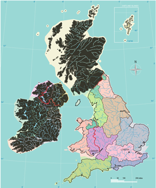
RBMPs in England and Wales
There are variations in the Plans specifically related to the situation in the devolved administrations and these can be found by clicking on the countries below:

The River Basin Management Plans, entitled
Water for Life and Livelihoods: River Basin Management Plan,
X River Basin District
(where X denotes any of the ten RBDs in England and Wales) have been produced by the Environment Agency, the , together with Liaison Panels, each representing a range of sectors appropriate for the river basin.
The River Basin Management Plans for England are found at:
(https://www.gov.uk/government/collections/river-basin-management-plans)
The Dee and Western Wales river basin districts are now managed by Natural Resources Wales.
The RBMP for the Dee is found at:
The RBMP for Western Wales is found at:
The plans for each of the 10 RBD in England and Wales have the same structure and consist of:
- The Main document
- A set of Annexes A to N
- – Current state of waters
- – Objectives for waters
- – Actions
- – Protected areas
- – Actions appraisal
- – Mechanisms for action
- – Pressures and risks
- – Climate change
- – Artificial and heavily modified waters
- – Other planning processes
- – Economic analysis
- – Consultation and engagement
- – Competent authorities
- – Glossary
- A Response document dRBMP consultation
- A Impact Assessment of the RBMP for the X River Basin District, revised November 2009
- A Habitats Regulations Assessment
- A Strategic Environmental Assessment of the RBMP for the X River Basin District
- A link to What’s in your backyard
Guide to the Annexes
The Main Consultation document
The contents page of the Main document indicates the key Chapters and lists the many Figures and Annexes related to the Plan.
- About this plan
- About the X River Basin District
- Water bodies and how they are classified
- The state of the water environment now
- Actions to improve the water environment by 2015
- The state of the water environment in 2015
- Targets for subsequent plans
- The X river basin district catchments
- Next steps – implementing this plan
- Summary statistics for the x River Basin District
- Further information – the annexes
Key Chapters
Chapter 4 ‘The water environment now’ and Chapter 6 ‘The state of the water environment in 2015’ give useful overviews at the RBD level of the current status classification and the future objectives until 2015. Chapter 5 ‘ Actions to improve the water environment by 2015’ gives an overview of the key contributions from sectors and organisations that the Environment Agency will work with to implement the plan. The full programme of actions can be found in Annex C. The following significant issues are most frequently identified in River Basin Districts in England and Wales:
- Rural and urban diffuse pollution (including transport)
- Point source pollution
- Flow problems
- Alien species
- Physical modifications
Chapter 8 ‘The X river basin district catchments ’ gives overview information on the status of waters now, the objectives proposed, and key actions proposed on a catchment by catchment basis. Detailed information about classification, on a water body by water body basis, including which elements of classification are causing failure of good status, is presented in the extensive Annex B.
Chapter 9 ‘ Next Steps – implementing this plan’ sets out steps how the plan is to be implemented under the following headings:
- Diffuse pollution investigation and action
- Additional national measures
- Implementing the plans at catchment level
- Working with co-deliverers
- Reporting on progress
- River basin management milestones
The Annexes
The Annexes to the Main document give more detail on the conditions in the river basin district, the actions proposed and the mechanisms that can be used to take forward these actions.
In particular, in order to understand the classification system used to assess the conditions of surface and groundwaters and to set future objectives, it is useful to consult Annex A: ‘Current state of waters in X River Basin District’ which describes the current status of surface waters and groundwater using labelled maps of the river basin district.
How do you find what the main concerns are in your locality?
You can look at ‘What’s in your backyard’ on the Environment Agency website. This sets out environmental data and maps for England and Wales at a local level, including information for river basin management plans:
|
|
|
|
|
You are here:

Tel: +44 (0) 1628 891 589 Fax: +44 (0) 1628 472711
Registered Office: Allen House, The Listons, Liston Road, Marlow,
Buckinghamshire SL7 1FD, UK © 2015 FWR All rights reserved.
The Foundation for Water Research is a company limited by guarantee,
registered in England, No 525927 and a registered charity No 1086685.